Specific Map Locations
by Carl Betsill ....see Map Info, Map Accuracy, & Full Map. Cities, Base Camps, Airfields, FSB (Fire Support Bases), special names areas
see Google Map view of Areas of Operation & Google Interactive Events Map - - Get 1:50,000 Topo Maps
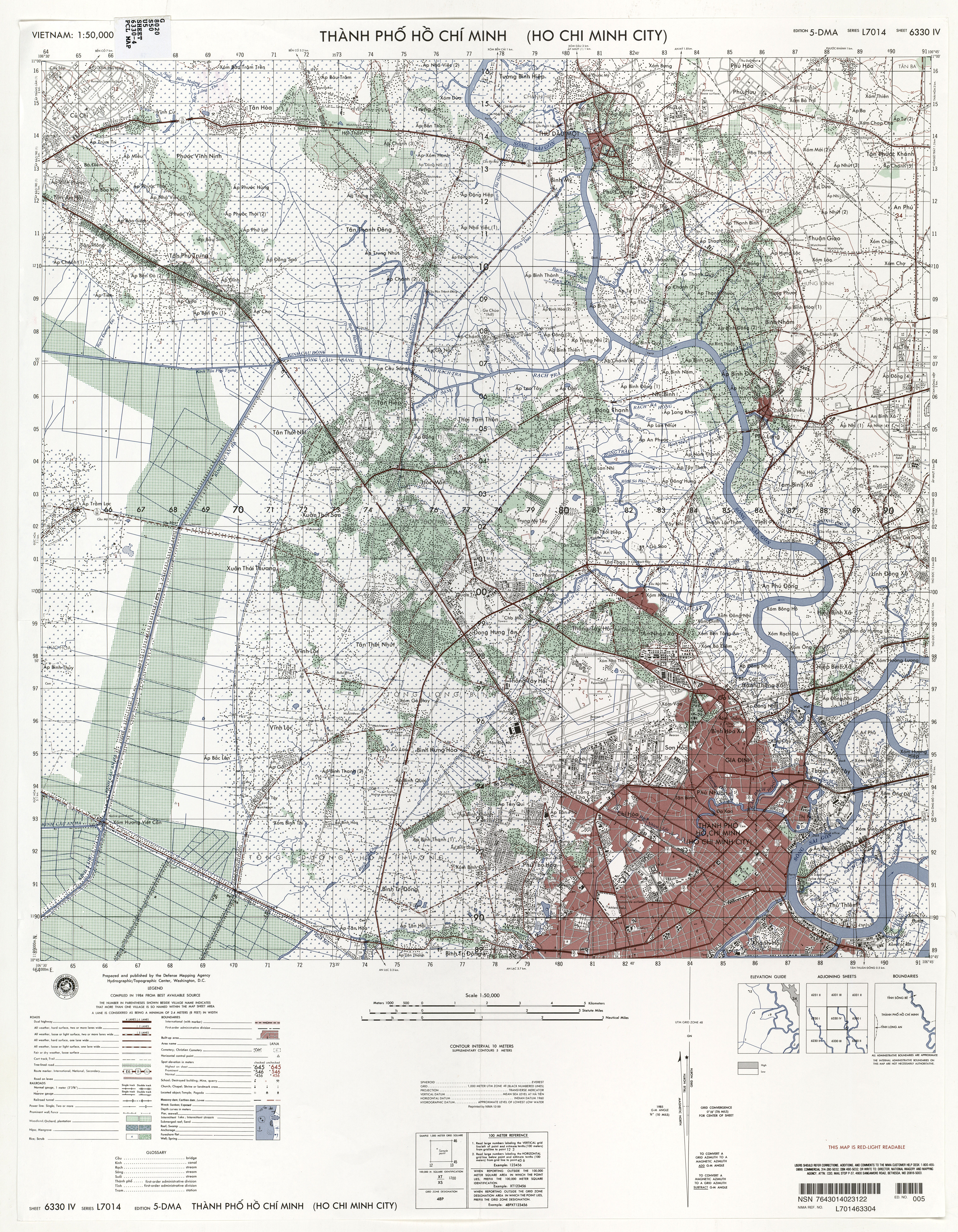
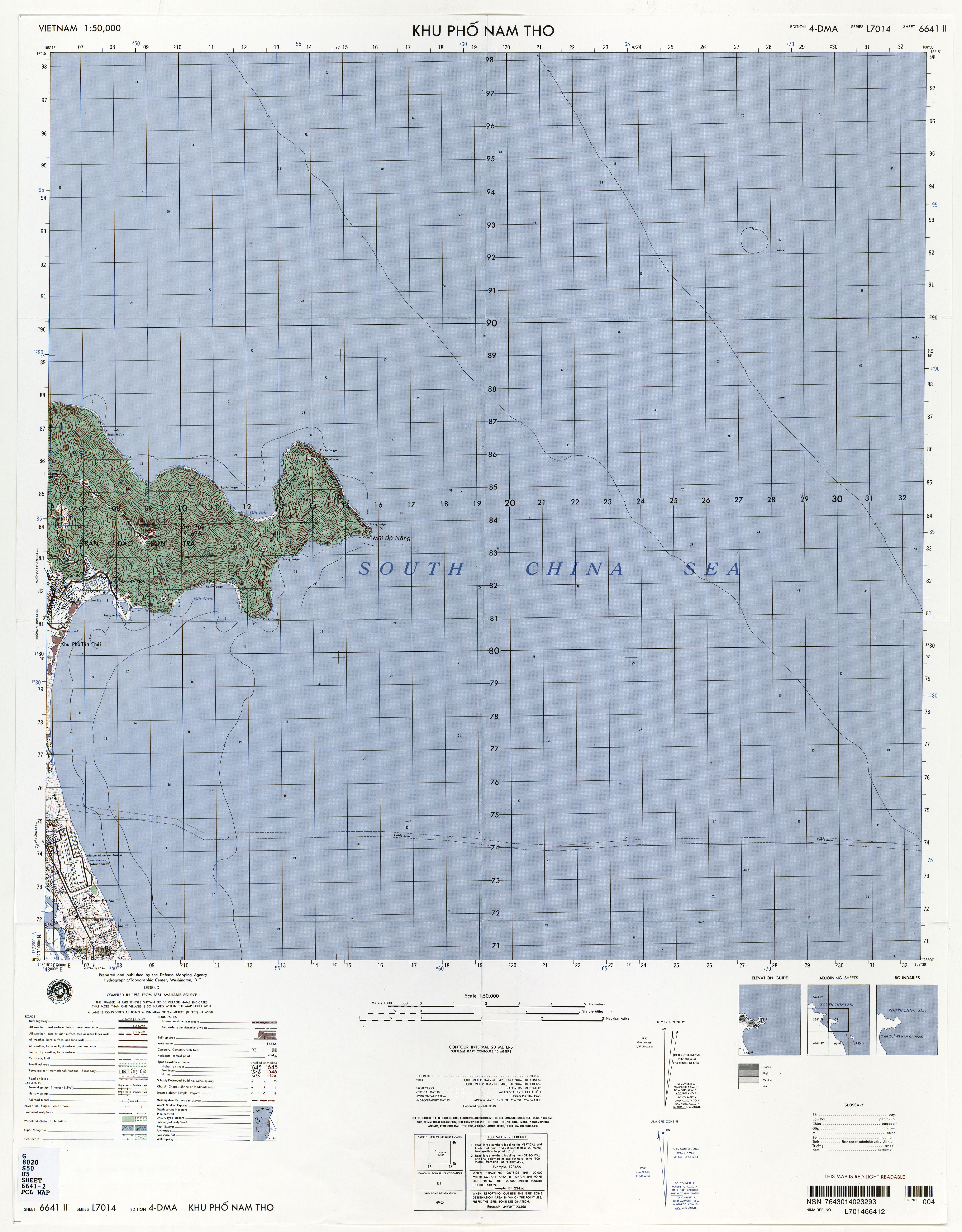
Use this table to find original Topographical Maps. Copy Google Earth Coordinates and paste into the Google Earth Search box to see how that area looks today. Features highlighted in Bold are where Centaur personnel were stationed. 1 Sep 2020
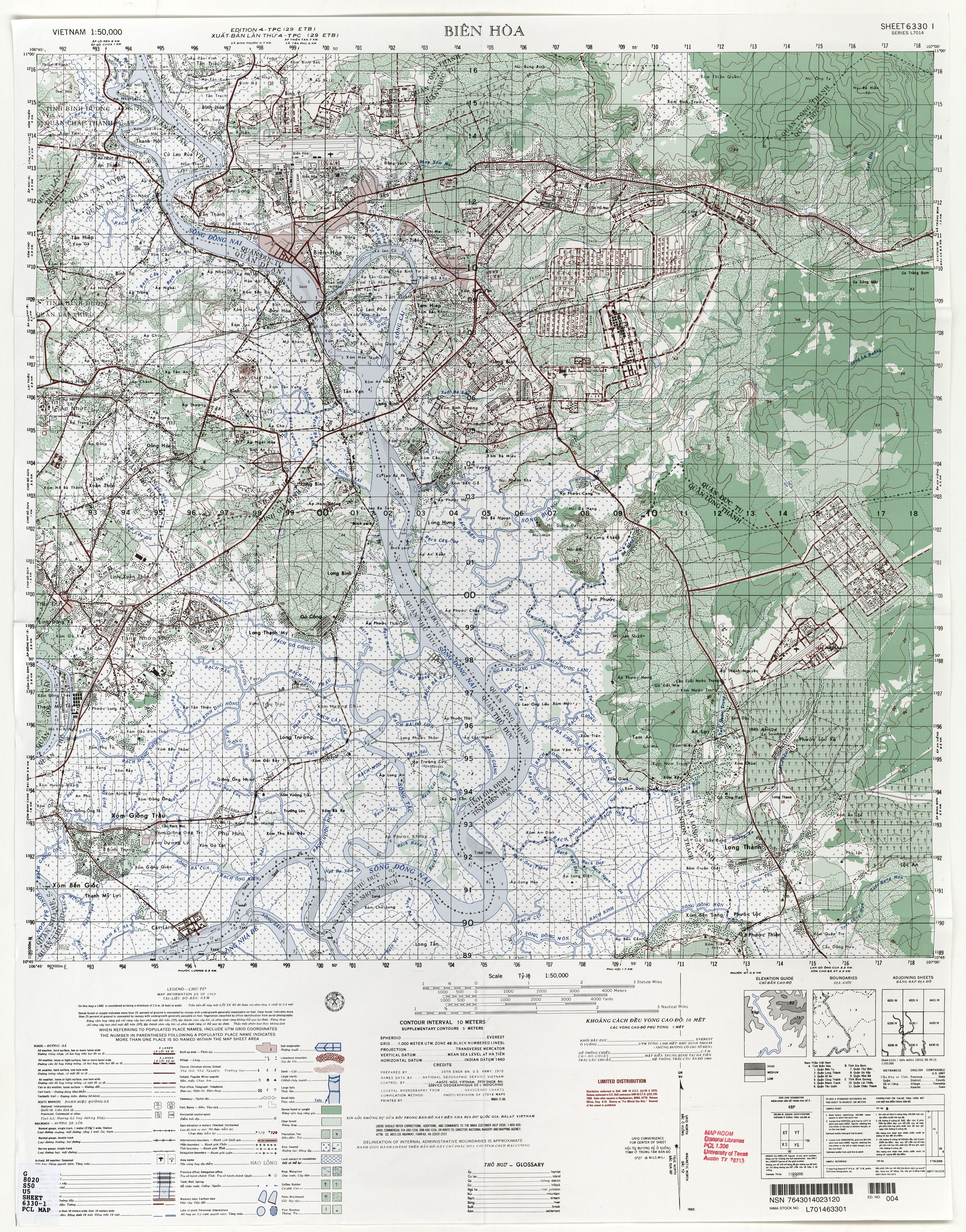
| Bien Hoa Air Base | 6330-1 | XT993136 | 10.975392,106.818736 | Looks usable but could see no aircraft parked at hangers. Old covered revetments are still there. |
Camp Eagle |
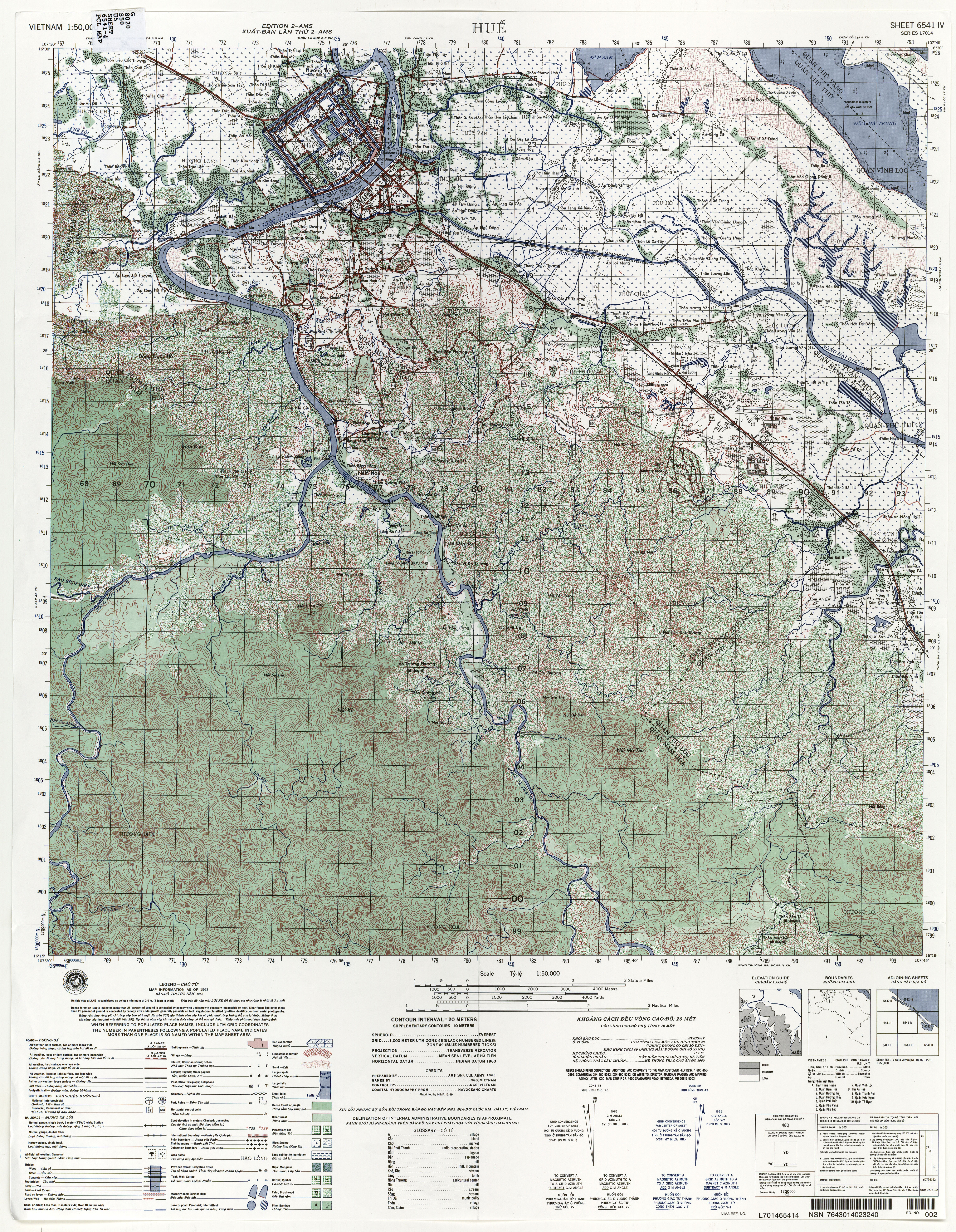
6541-4 | YD808165 | 16.408000,107.631000 | |
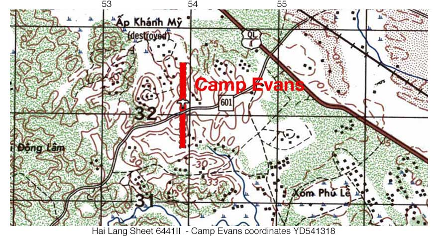
| Camp Evans | 6442-1 | YD539321 | 16.561910,107.374966 | Remnant of runway. |
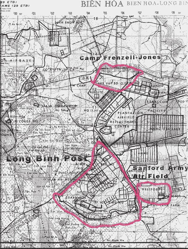
| Camp Frenzell-Jones | 6330-1 | YT055125 | 10.968824,106.881838 | This was the site of the transition of D-Troop to F Troop after moving from Chu Chi and prior to moving to Lai Khe. |
| Chu Chi Base | 6330-4 6331-3 6231-2 6231-1 |
XT657154 | 10.994874,106.513048 | Remnant of runway visible in Google products. Topo Map shows runway but some parts of the base are on adjoining sheets. |
Dau Tieng Air Field |
6231-1 | XT492472 | 11.283069,106.364602 | Remnants of the runways visible |
| FSB Bastogone | YD330083 | 16.348805,107.449927 | 1LT Frank Walker flew a LOH there to extract two ARVN advisors. The advisors told him not to land because the ARVN’s would storm the aircraft and no one would get out, so he left. It’s assumed the Advisers were KIA as the NVA overran the base. | |
| FSB Pedro | YD245486 | 16.710009,107.105986 | April 72 the NVA captured it. Cpt Ron Radcliffe and SP5 Tom Youngblood spotted a Chicom tank near there with the lid up. Radcliffe told Youngblood to put some rounds down the hatch just in case. Tom fired about 200 rounds. Interestingly, Tom spotted that exact tank on display somewhere in the US years later. | |
| FSB T-Bone | YD652202 | 16.451429,107.479930 | ||
| Go Dau Ha | XT415242 | 11.072490,106.293916 | A large element of D-Troop was temporally housed here. See The Suicide by Tom Fleming. Note the villiage of Go Dau Ha as seen on Topographic war era maps no longer exist. Today, a village by the same name is located further west almost on the Cambodian border. Currently, the nearest villiage to Go Dau Ha (1969) is Tran Vong 2. | |
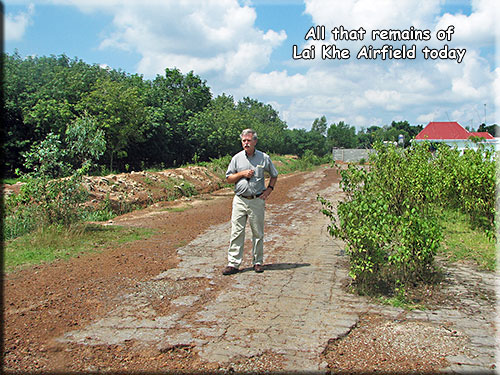
| Lai Khe Air Field | XT775383 | 11.201839,106.622031 | Nothing visible from the air. There are remnants of an asphalt strip in a vacant lot just east of QL-13. Tours guides may identify the runway as a dirt strip further east, but the runway was directly adjacent to and east of QL-13, leaving accuracy of the some tours in doubt. Lai Khe today. | |
| Lai Khe MACV HQ | XT765376 | 11.194460,106.612742 | This area is now home to the Vietnam Rubber Research Institute. | |
| Loc Ninh | XU732082 | 11.830213,106.586047 | ||
| LZ Sally | YD639275 | 16.518164,107.468058 | This is where Maj. Spencer, the creew, and the Blues were taaken to after his slick lost the engine andf broke off part of the tail boom. Also home of Aircraft serial number 66-17795 from May 68 until Dec 70. Better known to F-Troopers as Wargasm | |
| Marble Mountain Airfield | BT065737 | 16.026231,108.253449 | One airstrip visible and may still be in use. Old covered revetments clearly visible on the south end. Those with Google Earth, if you go to layers and activate “Photos”, you can see a picture of what appears to be one of our cobras, Look at photo nearest the revetments. | |
| Michelin Rubber Plantation Swimming Pool | XT488472 | 11.279363, 106.363340 | The above ground swimming pool of the Michelin Rubber plantation is still there but totally modernized.” see Return April 2016 |
|
| Phu Bai Air Field | YD885147 | 16.397270,107.700331 | Still an active Air Field | |
| Phuc Vinh Air Field | XT964497 | 11.299593,106.791989 | ||
| Phu Loi Base | XT860160 | 10.999023,106.698887 | The old base can be clearly seen on both topo maps and Google Earth views. A loose surface runway can also be seen 2 Km SW nearer the village of Phu Loi. This runway can also be seen in both.. | |
| Quan Loi Air Field | XT819909 | 11.674237,106.664120 | ||
| Sanford Army Air Field (Long Binh) | YT074068 | 10.915125,106.893851 | Little remains visible. The area is covered in what appears to be blue roofed warehouses. Long Binh Base itself is to the W in the triangle between QL15, 51, and QL1 highways. | |
| Tan My | 6542-3 | YD807335 | 16.567330,107.631163 | It appears part of the flight line has been asphalted and the old motor pool imprint is still there.. (Photos back to 2008 show the peninsular is growing rapidly on the North end.) Due to error in the U. Texas website, 6443-3 is shown in place of 6542-3. Full coordinate citation for this site is 48QYD807335.) see Lost Weapons of Tan My |
| Tay Ninh East | XT203510 | 11.317030,106.096446 | Nothing visible of the runway. Google photos in the area identify it as Camp Nguyễn Huệ. I’m just hoping I got this one right. At least there was an airfield here on the topo maps of the time and it seemed to be in the right location. Interesting that this is labeled on Topo as “Tay Ninh City Playground”. Maybe that’s why so many kids were always around. This airstrip was used by F-Troop in late 1971 to conduct missions into Cambodia. | |
| Tay Ninh West Base | XT168518 | 11.325450,106.066852 | Remnant of runway. In early 1967 D-Troop moved here temporarily to conduct special operations. | |
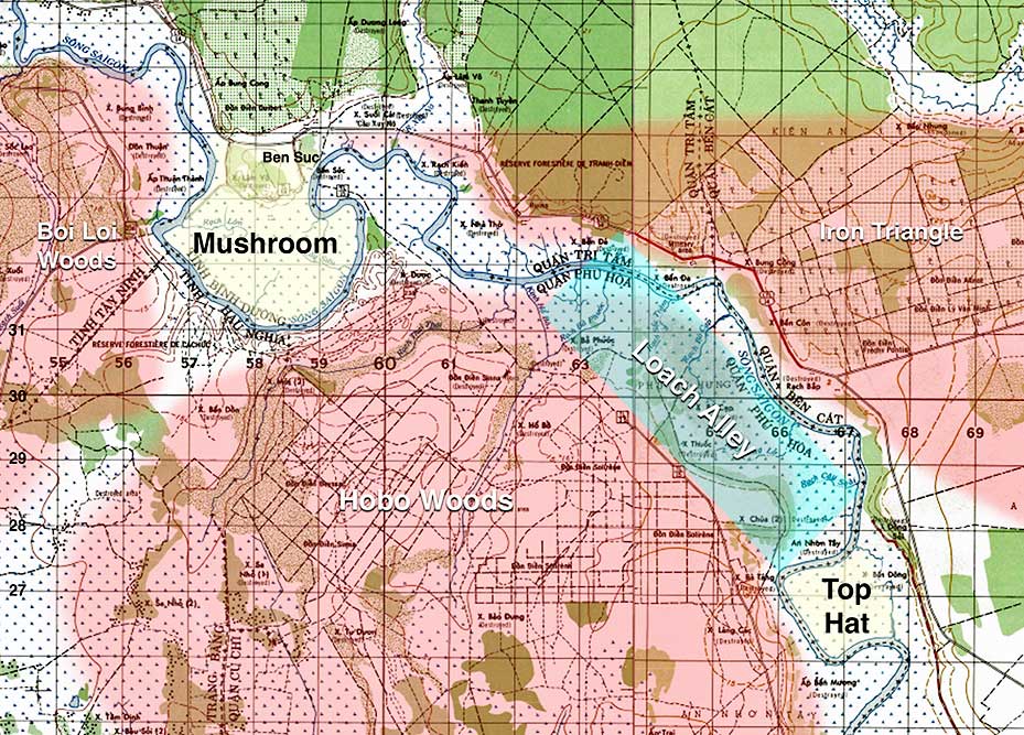
| The Mushroom | XT580320 | 11.143092,106.446512 | I’ve heard the bend on the down river side referred to as Snoopy from the Peanuts cartoon. | |
| The Top Hat | XT670270 | 11.097512,106.521963 | Area between here and Mushroom called LOH Alley. See Scout KIA | |
| Toule Cham Air Field | XT616816 | 11.580563,106.480209 | ||
| Action Report: 10 Nov 72 | AT812998 | 16.258012,108.017611 | F Troop 4th Cavalry engaged an enemy company-sized element (AT812998) equipped with .51 caliber weapons resulting in three enemy KBH. | |
| Action Report 15 Nov 72 | 379662 | 16.867112,107.232953 | F Troop 4th Cavalry observed two T54 tanks, two Soviet armored personnel carriers and four trucks one mile south of Qua Viet River (YD379662). During the engagement the team received heavy automatic weapons fire and one SA-7 was launched by enemy ground troops forcing the aircraft to depart prior to making a damage assessment of enemy forces. | |
| Action Report: 17 Oct 72 | YD558035 | 16.298911,107.393844 | F/4 destroyed two NVA trucks at YD558035. (Wayne Moose as Scout flew on this mission and spotted these trucks) | |
| Action Report: 22 Jul 72 | YD383646 | 16.852619,107.236535 | F/4 destroyed one soviet-built tracked vehicle at YD383646 | |
| Action Report: 31 Dec 72 | YD330711 | 16.905466,107.194929 | A light reconnaissance team from F Troop 4th Cavalry observed four tanks and 20 troops at YD338704 The team adjusted Naval gunfire with unknown results. | |
| Action Report: 6 Jan 73 | YD298704 | 16.945611,107.157849 | A light reconnaissance team conducting a bomb damage assessment of a B-52 strike (YD298748) observed trucks moving in the area. The team adjusted Naval gunfire resulting in five secondaries and six sustained fires. (F/4?) | |
| Action Report: 8 Jan 73 | YD3155 | 16.766635,107.167072 | A UH1-H aircraft from the 62nd Aviation Company while flying in support of the Vietnamese Airborne Division was reported shot down in enemy held territory northwest of Quang Tri (vic YD3155 (indicates at point within a 1 Km square)16.766635,107.167072). Field reports indicated the the aircraft was hit by small arms fire and an SA-7 missile. Negative contact was established with the crew and repeated attempts to locate the aircraft were unsuccessful. USAF aircraft participating in search and rescue efforts reported intense antiaircraft fire and numerous SA-7 firings throughout the area. The search and rescue operation was terminated with negative results and four crew members and two passengers were listed as missing in action. |
Full South Vietnam Map: